SL2-10-250 (May-June 1973) --- A vertical view of eastern Iowa and northwestern Illinois, as photographed from Skylab space station in Earth orbit. Davenport, Burlington and Muscatine, Iowa; and Rock Island and Moline, Illinois can be delin…
Eastern Iowa, Northwestern Illinois
U.S. Secretary of Agriculture Thomas Vilsack gives remarks prior to signing a memorandum of understanding between NASA and USDA, Wednesday, June 21, 2023, at the USDA’s Jamie L. Whitten Building in Washington. The agreement strengthens the…
NASA and USDA Sign Memorandum of Understanding
STS040-614-066 (5-14 June 1991) --- St. Louis, Missouri-East St. Louis, Illinois and surrounding area were photographed by the STS 40 crewmembers aboard the Space Shuttle Columbia.  The winding Mississippi River serves as a reference point…
St. Louis, MO, USA
STS035-73-082 (2-10 Dec 1990) --- This agricultural and ranching area, Rio Sao Francisco, Brazil (13.0S, 43.5W) has been under study for several years. See scene STS-31-92-045 for comparison. This area has many small single family subsisten…
Agricultural and Ranching area, Rio Sao Francisco, Brazil
As one of the best ever views of the city of New Orleans, LA (30.0N, 90.0W) from space, this image allows the study of the city and the region in minute detail. Major city street and highway patterns can easily be traced. Even the Superdome…
New Orleans, Louisiana
Tenarife Island is one of the most volcanically active of the Canary Island archipelago, Atlantic Ocean, just off the NW coast of Africa, (28.5N, 16.5W). The old central caldera, nearly filled in by successive volcanic activity culminating…
Tenarife Island, Canary Island Archipelago, Atlantic Ocean
U.S. Secretary of Agriculture Thomas Vilsack gives remarks prior to signing a memorandum of understanding between NASA and USDA, Wednesday, June 21, 2023, at the USDA’s Jamie L. Whitten Building in Washington. The agreement strengthens the…
NASA and USDA Sign Memorandum of Understanding
Chavonda Jacobs-Young, undersecretary of Agriculture for research, education and economics, gives remarks at an event where NASA Administrator Bill Nelson and U.S. Secretary of Agriculture Thomas Vilsack signed a memorandum of understanding…
NASA and USDA Sign Memorandum of Understanding
SL2-05-397 (22 June 1973) --- New Orleans, Louisiana, Mississippi River, and Lake Pontchartrain (31.0N, 91.0W) can all be seen in this single detailed view. The marshlands of the Atchafalaya Basin, previously the main drainage way for the M…
New Orleans, Louisiana, Mississippi River, and Lake Pontchartrain
In Saudi Arabia, center-pivot, swing-arm irrigated agriculture complexes such as the one imaged at Jabal Tuwayq (20.5N, 45.0 E) extract deep fossil water reserves to achieve food crop production self sufficiency in this desert environment.…
Irrigated Agriculture, Saudi Arabia
The Nile River Delta of Egypt (30.0N, 31.0E) irrigated by the Nile River and its many distributaries, is some of the richest farm land in the world and home to some 45 million people, over half of Egypt's population. The capital city of Cai…
Nile River Delta, Egypt
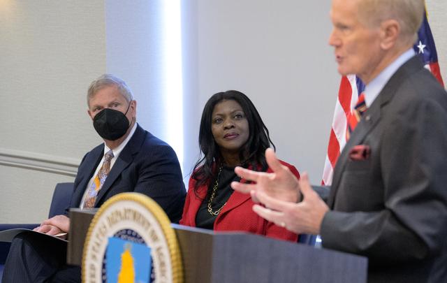
NASA Administrator Bill Nelson gives remarks prior to signing a memorandum of understanding between NASA and USDA, Wednesday, June 21, 2023, at the USDA’s Jamie L. Whitten Building in Washington. The agreement strengthens the collaboration…
NASA and USDA Sign Memorandum of Understanding
NASA Administrator Bill Nelson gives remarks prior to signing a memorandum of understanding between NASA and USDA, Wednesday, June 21, 2023, at the USDA’s Jamie L. Whitten Building in Washington. The agreement strengthens the collaboration…
NASA and USDA Sign Memorandum of Understanding
NASA Administrator Bill Nelson gives remarks prior to signing a memorandum of understanding between NASA and USDA, Wednesday, June 21, 2023, at the USDA’s Jamie L. Whitten Building in Washington. The agreement strengthens the collaboration…
NASA and USDA Sign Memorandum of Understanding
Egypt's High Aswan Dam on the Nile River at the first cataracts, Nile River, (24.0N, 33.0E) was completed in 1971 to provide cheap hydroelectric power and to regulate the historically uneven flow of the Nile River. The contrast between the…
Nile River, Lake Nasser, Aswan Dam, Egypt
NASA Administrator Bill Nelson gives remarks prior to signing a memorandum of understanding between NASA and USDA, Wednesday, June 21, 2023, at the USDA’s Jamie L. Whitten Building in Washington. The agreement strengthens the collaboration…
NASA and USDA Sign Memorandum of Understanding
The large field patterns in this view of the Rio Sao Francisco basin, Brazil, South America, (11.5S, 43.5W) indicate a commercial agriculture venture; family subsistence farms are much smaller and laid out in different patterns. Land cleari…
Agriculture, Rio Sao Francisco, Brazil, South America
Evidence of a recent flash flood can be seen in the form of light brown sediment that flowed down gullies and mountain sides forming ponds of debris over agricultural areas in the broad valley near the town of Parras (26.5N, 102.5W). This p…
Flash Flood Trail near Parras, Coahuila, Mexico
U.S. Secretary of Agriculture Thomas Vilsack gives remarks prior to signing a memorandum of understanding between NASA and USDA, Wednesday, June 21, 2023, at the USDA’s Jamie L. Whitten Building in Washington. The agreement strengthens the…
NASA and USDA Sign Memorandum of Understanding
The city of Sapporo on the northernmost of the Japanese Home Island of Hokkaido (43.5N, 141.5E), host to the 1986 Winter Olympic Games is situated along the margin of a large valley which extends across the island from the Sea of Japan to t…
Sapporo, Hokkaido, Japan
STS040-151-126 (5-14 June 1991) --- Croplands of the San Luis Valley stand out exceptionally clearly from low Earth orbit.  The Rio Grande flows through the valley.  Circular center pivot irrigation patterns have almost completely replaced…
Great Sand Dune National Monument, CO, USA
Agricultural patterns are distinctly visible in this near-vertical false color infrared photography taken in November 1994. The area depicted on the photograph is south of Khartoum between the White and Blue Nile Rivers. By far the most imp…
Sudan, Africa as seen from STS-66 shuttle Atlantis
This oblique view of Lake Chad was taken by the STS-66 crew in November 1994. This lake lies mainly in the Republic of Chad and partly in Nigeria, Cameroon and Niger. The size of Lake Chad varies seasonally and is actually divided into nort…
Lake Chad, Chad as seen from STS-66
STS054-152-189 (13-19 Jan. 1993) --- This near-vertical color photograph shows the very diverse landscape that is part of the great Sahara Desert of north Africa.  Specifically, the vast expanse of sand dunes, located in the extreme southwe…
Murzuk Sand Sea, Sahara Desert, Libya, Africa
Mt. Pinatubo on the island of Luzon (15.0N, 120.0E) erupted catastrophically in June 1991 after over 600 years of inactivity. In this vertical view, the full extent of the eruption is obvious. Thick layers of ash completely surrounds the cr…
Mt. Pinatubo Volcano - Post Eruption, Luzon, Philippines
STS060-92-082 (3-11 Feb 1994) --- This cloud-free view is centered on the city of Baghdad, Iraq.  Baghdad has had a reputation for scholarship and learning from ancient times in the Islamic world.  Modern Baghdad is a city with a typical ur…
Baghdad, Iraq as seen from STS-60
STS040-152-180 (5-24 June 1991) --- The Sinai Peninsula dominates this north-looking, oblique view.  According to NASA photo experts studying the STS 40 imagery, the Red Sea in the foreground is clear of river sediment because of the prevai…
Southeastern Mediterranean Panorama
NASA Administrator Bill Nelson gives remarks prior to signing a memorandum of understanding between NASA and USDA, Wednesday, June 21, 2023, at the USDA’s Jamie L. Whitten Building in Washington. The agreement strengthens the collaboration…
NASA and USDA Sign Memorandum of Understanding
STS-56 Earth observation of the northeastern Nile Delta was photographed from the Earth-orbiting Discovery, Orbiter Vehicle (OV) 103. The branch of the Nile featured in the frame is Daimietta. The Suez Canal marks the boundary of the Nile D…
STS-56 Earth observation of the northeastern Nile Delta
Marlen Eve, Deputy Administrator for the Agricultural Research Service at the U.S. Department of Agriculture (USDA), speaks before the ribbon cutting ceremony to open NASA’s Earth Information Center, Wednesday, June 21, 2023, at the Mary W.…
NASA’s Earth Information Center Ribbon Cutting
SL3-88-053 (July-September 1973) --- A near vertical view of the Tennessee-Virginia-Kentucky border area is seen in this Skylab 3 Earth Resources Experiments Package S190-B (five-inch Earth terrain camera) photograph taken from the Skylab s…
View of Tennessee, Virginia, Kentucky border area
SL3-88-004 (July-September 1973) --- A vertical view of the Salinas River Valley area south of Monterey Bay, California area is seen in this Skylab 3 Earth Resources Experiments Package S190-B (five-inch Earth terrain camera) photograph tak…
View of the Salinas River Valley area south of Monterey Bay, California
SL4-92-300 (February 1974) --- A near vertical view of the Mobile Bay, Alabama area is seen in this Skylab 4 Earth Resources Experiments Package S190-B (five-inch earth terrain camera) photograph taken from the Skylab space station in Earth…
Mobile Bay, Alabama area seen in Skylab 4 Earth Resources Experiment Package
SL2-05-422 (22 June 1973) --- This section of the lower Mississippi River (34.0N, 90.0W) known as the Yazoo Basin, is characterized by a wide expanse of rich river bottomland with many oxbow lakes, the remains of the many changes in the riv…
Mississippi River, Yazoo Basin, Memphis, TN
51F-32-024 (29 July - 6 August 1985) --- Italy's “boot heel" surrounded by waters of the Ionian Sea/Golfo di Taranto and the Adriatic Sea is very clearly visible in this scene made with a handheld 70mm camera. Spacelab 2's versatile i…
Southern Italy, Instrument Pointing Subsystem
STS054-86-001 (13-19 Jan. 1993) --- This 70mm view shows a spectacular multiple spit on the coast of Brazil, about halfway between Rio de Janeiro and the mouth of the Amazon River. Over a few thousand years, according to NASA scientists, sh…
Cape Baleia, Caravelas, Brazil
This color infrared view of Houston (29.5N, 95.0W) was taken with a dual camera mount. Compare this scene with STS048-78-034 for an analysis of the unique properties of each film type. Comparative tests such as this aids in determining the…
Color Infrared view of Houston, TX, USA
STS001-12-305 (12-14 April 1981) --- California, San Francisco Bay photographed by a crew member on the space shuttle Columbia (STS-1). The coast is seen from near Santa Cruz northward to Point Reyes. The great valley is in the foreground.…
California, San Francisco Bay area
This view of deforestation in Rondonia, far western Brazil, (10.0S, 63.0W) is part of an agricultural resettlement project which ultimately covers an area about 80% the size of France. The patterns of deforestation in this part of the Amazo…
Deforestation, Rondonia, Brazil
This color photo view of Houston (29.5N, 95.0W) was taken with a dual camera mount for comparitive film type testing. Compare this scene with STS048-106- 034 for an analysis of the unique properties of each type. Comparitive tests such as t…
Houston, TX, USA
The Bight of Bangkok and the city of Bangkok, Thailand are visible in this west looking view. The city of Bangkok, with an estimated population in excess of 3.7 million people, can be seen in the lower right-hand corner of the view. The cit…
Infrared view of Bangkok, Thailand
SL2-03-200 (22 June 1973) --- The city of Phoenix, AZ (33.5N, 112.0W) can be seen in good detail in this color infrared scene. Situated among truck crop agriculture fields, the color infrared photo depicts the vegetated fields as shades of…
Phoenix, AZ, USA
This near vertical photograph illustrates the differences in agricultural land patterns typically seen in many parts of southwestern Brazil, near the Bolivian border. The larger rectangular field patterns reflect a mature, fully developed a…
Deforestation in Brazil as seen from STS-66 Atlantis
SL3-84-202 (July-September 1973) --- A vertical view of the Montevideo, Uruguay area of South America is seen in this Skylab 3 Earth Resources Experiments Package S190-B (five-inch Earth terrain camera) photograph taken from the Skylab spac…
View of Montevideo, Uruguay area of South America
NASA Administrator Bill Nelson signs a memorandum of understanding between NASA and USDA, as Undersecretary of Agriculture for research, education and economics, Chavonda Jacobs-Young, looks on, Wednesday, June 21, 2023, at the USDA’s Jamie…
NASA and USDA Sign Memorandum of Understanding
STS059-S-086 (18 April 1994) --- This is a three-frequency false-color image of Flevoland, the Netherlands, centered at 52.4 degrees north latitude, and 5.4 degrees east longitude.  This image was acquired by the Spaceborne Imaging Radar-C…
Three frequency false color image of Flevoland, the Netherlands
U.S. Secretary of Agriculture Thomas Vilsack, left, and NASA Administrator Bill Nelson, pose for a photograph after having signed a memorandum of understanding, Wednesday, June 21, 2023, at the USDA’s Jamie L. Whitten Building in Washington…
NASA and USDA Sign Memorandum of Understanding
U.S. Senator Kay Bailey Hutchison, R-Texas looks on as Secretary of Agriculture Ed Schafer, left, shakes hands with NASA Administrator Michael Griffin after signing a memorandum of understanding (MOU) between NASA and USDA Wednesday, July 2…
USDA Memorandum of Understanding Signing