
Widespread agricultural burning continues throughout central Africa. Smoke and fires in several countries were seen by the Suomi NPP satellite. Most of the fires were burning in the southern region of the Democratic Republic of the Congo, T…
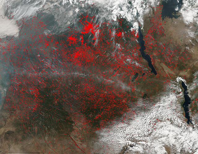
NASA’s Suomi NPP satellite detected thousands of fires burning in central Africa on July 11, 2016. The fires are represented by the multitudes of red dots. Most of the fires burn in grass or cropland. The location, widespread nature, and nu…

Africa is front and center in this image of Earth taken by a NASA camera on the Deep Space Climate Observatory (DSCOVR) satellite. The image, taken July 6 from a vantage point one million miles from Earth, was one of the first taken by NASA…

iss071e378517 (July 21, 2024) --- Mount Kilimanjaro, surrounded by clouds and the highest mountian in Africa, is pictured from the International Space Station as it orbited 261 miles above the Indian Ocean off the coast of Tanzania.

STS039-151-193 (28 April-6 May 1991) --- The Strait of Gibraltar, the only outlet for the Mediterranean Sea, was photographed with a large format handheld camera by the STS-39 crew members. Scientists site evidence in Shuttle photography th…

Tanguay Gahouma Bekale, director general of the Gabonese Space Agency, talks to media about the AfriSAR mission.

Members of the AfriSAR team standing by the C-20A in Gabon, Africa, which is usually based at NASA Armstrong Flight Research Center in California include, from left, John McGrath, Carlos Meza, Stu Broce, Samuel Choi, David Fedors, Naiara Pi…

STS054-151-009 (13-19 Jan 1993) --- This large format camera's view shows the circular volcanic structure of the Brandberg mountain, which at 2630 meters (8,550 feet) is the highest point in the new nation of Namibia. The Brandberg is a ma…

Goddard Space Center’s Laura Duncanson records global positioning satellite coordinates of the Pongara Mangrove and tree heights and diameters.

Africa Flores, Land Cover and Land Use Change Theme Lead for SERVIR, speaks during the 2018 Annual Earth Science Applications Showcase, Wednesday, Aug. 1, 2018 at NASA Headquarters in Washington. Every summer students and young professional…

Solar eclipse over western Africa (morning overpass) at 11:45 UTC. Satellite: Terra A rare “hybrid” solar eclipse occurred on 03 November 2013, which began over the western Atlantic Ocean as an annular eclipse and transitioned into a full…

Mark Scherer prepares the C-20A for the AfriSAR mission.

Armstrong Pilots David Fedors and Stu Broce are at the controls of the C-20A in March 2016 as it flies a synthetic aperture radar over areas of interest in the AfriSAR mission based in Gabon, Africa. The international campaign included meas…

During an education outreach event in Gabon, Africa, students and educators, look at the German Aerospace Center Dornier DO-228 twin-engine turboprop aircraft.

NASA researchers walk through the Mondah rainforest to collect tree and flora measurements and other data as part of the AfriSAR mission.

STS058-88-017 (18 Oct-1 Nov 1993) --- The eye-catching "bullseye" of the Richat Structure adds interest to the barren Gres de Chinguetti Plateau in central Mauretania, northwest Africa. It represents domally uplifted, layered (sedimentary)…

In Gabon, Africa, the Mondah National Park is one of the field research sites for NASA’s AfriSAR campaign. Gabon is a Central African country slightly smaller than the state of Colorado that features the world’s second largest rainfores…
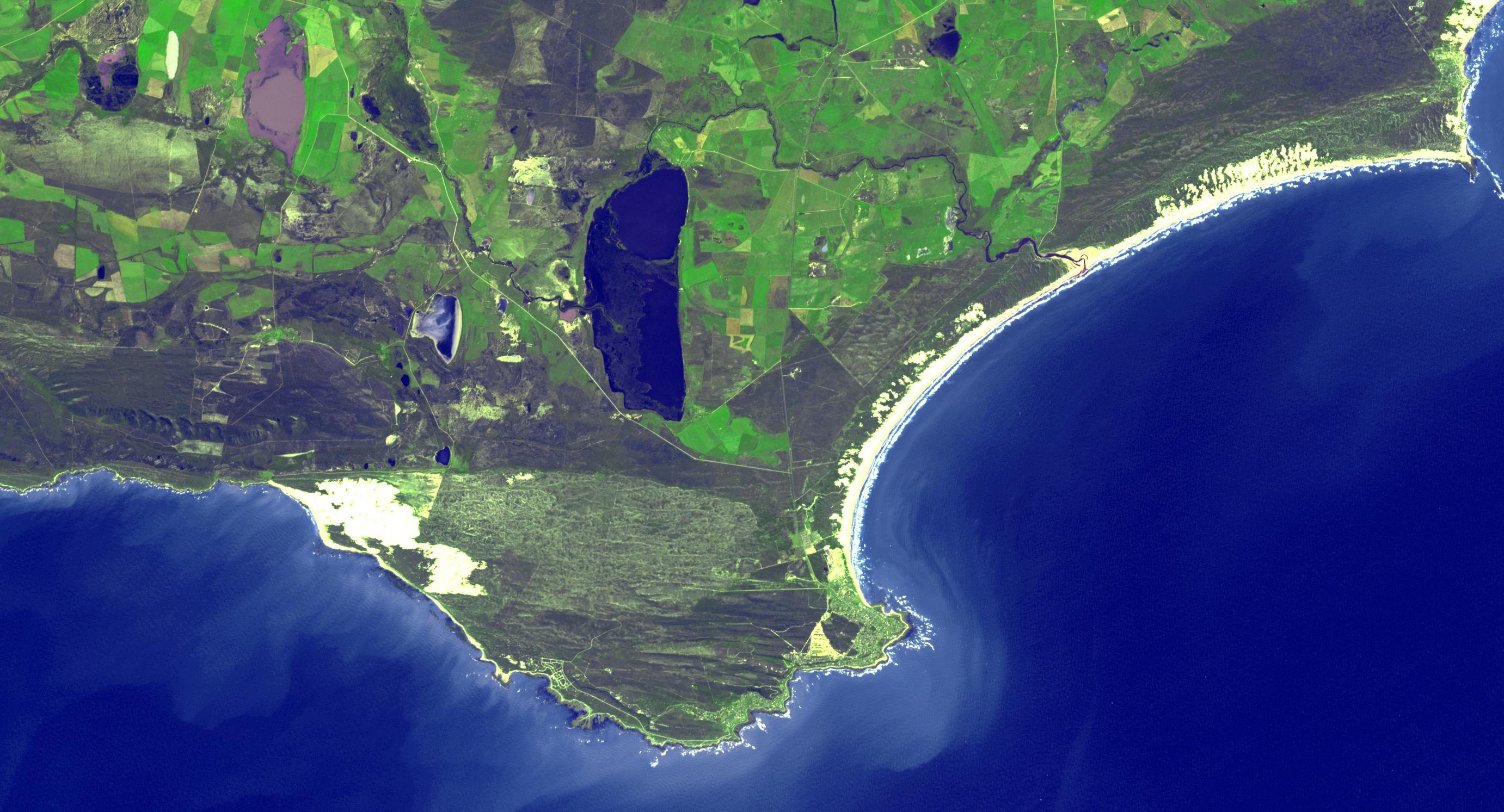
The southernmost tip of Africa is marked by the Cape Agulhas lighthouse. The warm Atlantic Agulhas current meets the cold water Indian Ocean Benguela current, creating treacherous seas that have claimed many ships over the last 450 years. T…

Africa is front and center in this image of Earth taken by a NASA camera on the Deep Space Climate Observatory (DSCOVR) satellite. The image, taken July 6 from a vantage point one million miles from Earth, was one of the first taken by NASA…

On April 23, 2013 NASA’s Terra satellite passed off the coast of West Africa, allowing the Moderate Resolution Imaging Spectroradiometer (MODIS) flying aboard to capture a curious phenomenon over the cloud deck below. The rainbow-like disco…

This is an image of equatorial Africa, centered on the equator at longitude 15degrees east. This image is a mosaic of almost 4,000 separate images obtained in 1996 by the L-band imaging radar onboard the Japanese Earth Resources Satellite.…

STS061-106-091 (December 1993) --- The entire southern tip of Africa is shown in this high altitude 50mm photograph. The center of the photograph is at approximately 28.0 degrees south and 24.0 degrees east Cape Columbine is at the upper r…

AfriSAR team members Sassan Saatchi (left) from NASA’s Jet Propulsion Laboratory and Laura Duncanson from NASA’s Goddard Space Flight Center take measurements of trees in the rainforest in the Mondah National Park, Gabon, Africa.

C-20A crew chief Vince Moreno inspects the aircraft.

A member of the Gabon National Park Agency Ecoguard discussed the next research destination with Lola Fatoyinbo, Marc Simard and Laura Duncanson.

Solar eclipse over western Africa (afternoon overpass) at 14:45 UTC. Satellite: Aqua A rare “hybrid” solar eclipse occurred on 03 November 2013, which began over the western Atlantic Ocean as an annular eclipse and transitioned into a ful…

Agricultural patterns are distinctly visible in this near-vertical false color infrared photography taken in November 1994. The area depicted on the photograph is south of Khartoum between the White and Blue Nile Rivers. By far the most imp…

Marc Simard of the Jet Propulsion Laboratory installs a gauge that will record water level changes in the Pongara Mongrove.

STS054-152-189 (13-19 Jan. 1993) --- This near-vertical color photograph shows the very diverse landscape that is part of the great Sahara Desert of north Africa. Specifically, the vast expanse of sand dunes, located in the extreme southwe…

AS17-148-22717 (7 Dec. 1972) --- This view of a portion of Earth was taken from the Apollo 17 spacecraft following trans-lunar insertion during the final lunar landing mission in NASA's Apollo Program. The visible land mass is the southern…

One of the driest regions on Earth, the Namib Desert, Namibia, Africa (23.0N, 15.0E) lies adjacent to the Atlantic coast but the upwelling oceanic water causes a very stable rainless atmosphere. The few local inland rivers do not reach the…

The Okoume’ tree grows tall above the other flora to reach for the suns energy.
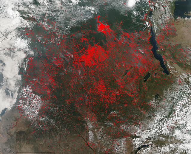
The Suomi NPP satellite's Visible Infrared Imaging Radiometer Suite (VIIRS) instrument captured a look at huge numbers of fires burning and the resulting smoke in central Africa on June 27, 2017. Actively burning areas, detected by VIIRS…

On June 26, 2016, the Moderate Resolution Imaging Spectroradiometer (MODIS) on NASA’s Terra satellite acquired this natural-color image of cloud gravity waves off the coast of Angola and Namibia. “I [regularly] look at this area on Worldvi…

Mangoro River on Madagascar's east coast leads to the Indian Ocean in this photograph from the Indian Ocean as it orbited 263 miles above

A piece of Africa—actually lots of them—began to arrive in the Americas in June 2014. On June 23, a lengthy river of dust from western Africa began to push across the Atlantic Ocean on easterly winds. A week later, the influx of dust was af…

STS062-151-182Z (4-18 March 1994) --- This east-looking view shows most of the east-west extent of the country of Sudan. The foreground shows a vegetation-less and almost uninhabited region of northwest Sudan. The rich earth colors are an…
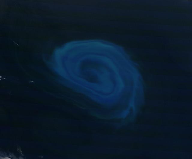
NASA image acquired December 26, 2011 Off the coast of South Africa, near where the South Atlantic meets the Southern Indian Ocean, a massive summer phytoplankton bloom colored the waters with a swirl of turquoise, green and white in late…

iss074e0103137 (Dec. 29, 2025) --- A SpaceX Dragon spacecraft fires its Draco engines, an independent propellant system located in the spacecraft’s trunk, for a regularly scheduled orbital reboost of the International Space Station. The orb…

AST-14-890 (18 July 1975) --- An oblique view of unique drainage patterns in southwestern Africa in the Rio Cuando area of Angola and South-West Africa, as photographed from the Apollo spacecraft in Earth orbit during the joint U.S.-USSR Ap…

In this panoramic view of the Okavango Swamp, Botswana, (19.0S, 22.0E), the Okavango River, seen in sunglint, flows into a topographic trough to form an inland delta. Water, trapped in the meandering delta distributaries is evaporated or tr…

NASA image acquired April 18 - October 23, 2012 This new image of Europe, Africa, and the Middle East at night is a composite assembled from data acquired by the Suomi NPP satellite in April and October 2012. The new data was mapped over e…

NASA’s C-20A takes off from Libreville International Airport in Gabon, Africa, in support of the AfriSAR  campaign in March 2016. Gabon is a Central African country slightly smaller than the state of Colorado that features the world’s…

Africa's Lake Chad where the borders of Chad, Niger, Nigeria and Cameroon merge (13.0N, 14.0E) has been undergoing change for the past 25 to 30 years when it was first noticed that the lake is drying up. Since then, astronauts have been pho…

The NASA Langley Research Center-based B-200 in Gabon, Africa, was visited by three representatives of the Gabon Ministry of the Numerical Economy (the three women seen in the middle). In the photo from left are Bryan Blair, Rick Yasky, the…

Sam Choi and Naiara Pinto observe Google Earth overlaid with in almost real time what the synthetic aperture radar is mapping from the C-20A aircraft. Researchers were in the sky and on the ground to take measurements of plant mass, distrib…

STS049-92-071 (13 May 1992) --- The STS-49 crew aboard the Earth-orbiting Space Shuttle Endeavour captured this Saharan dust storm on the Algeria-Niger border. The south-looking, late-afternoon view shows one of the best examples in the Sh…

STS054-152-001 (13-19 Jan 1993) --- View southeastward across the northern, arid coastal plain of Somalia from Dhul Hafun (Hafun Peninsula) on the extreme left to Ras (Cape) Illig on the extreme right. There are no good harbors, no permane…