One of three drones used in recent tests by NASA’s Jet Propulsion Laboratory in Southern California flies over Mars Hill, a region of Death Valley National Park, in September 2025. The region’s rubbly, volcanic rocks have served as a Mars-l…
Research Drone Flies Over Mars Hill
Jody Miller, left, Alex Godwin, and Jeff Strebler, right, prepares the L3Harris FVR90 Unmanned Aerial Vehicle (UAV) at the Monterey Bay Academy Airport near Watsonville, California.
Advanced Capabilities for Emergency Response Operations (ACERO)
The Alta-X Unmanned Aerial Vehicle (UAV) with camera payload in flight at the Monterey Bay Academy Airport near Watsonville, California.
Advanced Capabilities for Emergency Response Operations (ACERO)
The NASA Langley Alta-X Unmanned Aerial Vehicle (UAV) lifts off with a weather payload from the Monterey Bay Academy Airport near Watsonville, California, during the Advanced Capabilities for Emergency Response Operations (ACERO) Shakedown…
Advanced Capabilities for Emergency Response Operations (ACERO)
The SuperVolo XL Unmanned Aerial Vehicle (UAV) lifts off at the Monterey Bay Academy Airport near Watsonville, California.
Advanced Capabilities for Emergency Response Operations (ACERO)
Jonas Jonsson guides the Alta-X Unmanned Aerial Vehicle (UAV) with camera payload down to the landing pad at the Monterey Bay Academy Airport near Watsonville, California.
Advanced Capabilities for Emergency Response Operations (ACERO)
This rendering was created by research drones flying over Mars Hill, a region of Death Valley National Park that has been used by NASA’s Mars researchers since the 1970s, when the agency was preparing to land the twin Viking spacecraft. The…
Rendering of Mars Hill in Death Valley National Park
A drone show is seen during the Mars celebration Friday, May 31, 2019, in Mars, Pennsylvania. NASA is in the small town to celebrate Mars exploration and share the agency’s excitement about landing astronauts on the Moon in five years. The…
Mars Celebration
The drone follows an autonomously defined path around the modified C-141 Kuiper Airborne Observatory, (KAO) (NASA-714), on the N211 apron.  The drone photographs the aircraft with a visible and infrared camera which are processed using a ph…
Kuiper Airborne Observatory (KAO) Demolition
The drone follows an autonomously defined path around the modified C-141 Kuiper Airborne Observatory, (KAO) (NASA-714), on the N211 apron.  The drone photographs the aircraft with a visible and infrared camera which are processed using a ph…
Kuiper Airborne Observatory (KAO) Demolition
Richard Kolyer, left, with Jonas Jonsson guide the drone to land behind the modified C-141 Kuiper Airborne Observatory, (KAO) (NASA-714), on the N211 apron.
Kuiper Airborne Observatory (KAO) Demolition
Test of Unmanned Aircraft Systems Traffic Management (UTM) technical capability Level 2 (TCL2) at Reno-Stead Airport, Nevada. During the test, five drones simultaneously crossed paths, separated by altitude.  Two drones flew beyond visual l…
UTM Technical Capabilities Level 2 (TLC2) Test at Reno-Stead Airport.
Richard Kolyer, left, with Jonas Jonsson guide the drone to land behind the modified C-141 Kuiper Airborne Observatory, (KAO) (NASA-714), on the N211 apron.
Kuiper Airborne Observatory (KAO) Demolition
Test of Unmanned Aircraft Systems Traffic Management (UTM) technical capability Level 2 (TCL2) at Reno-Stead Airport, Nevada. During the test, five drones simultaneously crossed paths, separated by altitude.  Two drones flew beyond visual l…
UTM Technical Capabilities Level 2 (TLC2) Test at Reno-Stead Airport.
A researcher from NASA’s Jet Propulsion Laboratory in Southern California monitors a drone as it flies over sand dunes in September 2025. This image was captured in Death Valley National Park during a larger test campaign to develop navigat…
Drone Test Flight Over Sand Dunes
The work was among 25 projects funded by NASA’s Mars Exploration Program this past year to push the limits of future technologies. Sand dunes confused the navigation algorithm of the Ingenuity Mars helicopter during several of its last flig…
Researchers Test Mars Drone Software in Death Valley
DAST cockpit
DAST cockpit
The Alta-X Unmanned Aerial Vehicle (UAV) with camera payload in flight at the Monterey Bay Academy Airport near Watsonville, California.
Advanced Capabilities for Emergency Response Operations (ACERO)
Jonas Jonsson guides the Alta-X Unmanned Aerial Vehicle (UAV) with camera payload down to the landing pad at the Monterey Bay Academy Airport near Watsonville, California.
Advanced Capabilities for Emergency Response Operations (ACERO)
L3Harris FVR90 Unmanned Aerial Vehicle (UAV) lifts off from the Monterey Bay Academy Airport near Watsonville, California, during the Advanced Capabilities for Emergency Response Operations (ACERO) Shakedown Test as NASA researchers observe…
Advanced Capabilities for Emergency Response Operations (ACERO)
Silhouette view of Jonas Jonsson with the Alta-X Unmanned Aerial Vehicle (UAV) on the landing pad as the sun sets at the Monterey Bay Academy Airport near Watsonville, California.
Advanced Capabilities for Emergency Response Operations (ACERO)
L3Harris FVR90 Unmanned Aerial Vehicle (UAV) lifts off from the Monterey Bay Academy Airport near Watsonville, California, during the Advanced Capabilities for Emergency Response Operations (ACERO) Shakedown Test.
Advanced Capabilities for Emergency Response Operations (ACERO)
Brayden Chamberlain, preps the SuperVolo XL Unmanned Aerial Vehicle (UAV) for flight at the Monterey Bay Academy Airport near Watsonville, California.
Advanced Capabilities for Emergency Response Operations (ACERO)
A drone show is seen during the Mars celebration Friday, May 31, 2019, in Mars, Pennsylvania. NASA is in the small town to celebrate Mars exploration and share the agency’s excitement about landing astronauts on the Moon in five years. The…
Mars Celebration
The drone follows an autonomously defined path around the modified C-141 Kuiper Airborne Observatory, (KAO) (NASA-714), on the N211 apron.  The drone photographs the aircraft with a visible and infrared camera which are processed using a ph…
Kuiper Airborne Observatory (KAO) Demolition
Vigilant Aerospace Systems CEO Kraettli Epperson, left, and NASA Armstrong Flight Research Center Director David McBride, sign the agreement for the company to commercialize a large drone communication system for the Federal Aviation Admini…
ED16-0042-06
Test of Unmanned Aircraft Systems Traffic Management (UTM) technical capability Level 2 (TCL2) at Reno-Stead Airport, Nevada. During the test, five drones simultaneously crossed paths, separated by altitude.  Two drones flew beyond visual l…
UTM Technical Capabilities Level 2 (TLC2) Test at Reno-Stead Airport.
The drone follows an autonomously defined path around the modified C-141 Kuiper Airborne Observatory, (KAO) (NASA-714), on the N211 apron.  The drone photographs the aircraft with a visible and infrared camera which are processed using a ph…
Kuiper Airborne Observatory (KAO) Demolition
Test of Unmanned Aircraft Systems Traffic Management (UTM) technical capability Level 2 (TCL2) at Reno-Stead Airport, Nevada. During the test, five drones simultaneously crossed paths, separated by altitude.  Two drones flew beyond visual l…
UTM Technical Capabilities Level 2 (TLC2) Test at Reno-Stead Airport.
The drone follows an autonomously defined path around the modified C-141 Kuiper Airborne Observatory, (KAO) (NASA-714), on the N211 apron.  The drone photographs the aircraft with a visible and infrared camera which are processed using a ph…
Kuiper Airborne Observatory (KAO) Demolition
Test of Unmanned Aircraft Systems Traffic Management (UTM) technical capability Level 2 (TCL2) at Reno-Stead Airport, Nevada. During the test, five drones simultaneously crossed paths, separated by altitude.  Two drones flew beyond visual l…
UTM Technical Capabilities Level 2 (TLC2) Test at Reno-Stead Airport.
The work was among 25 projects funded by NASA’s Mars Exploration Program this past year to push the limits of future technologies. Sand dunes confused the navigation algorithm of the Ingenuity Mars helicopter during several of its last flig…
Researchers Monitor Drone Testing in Death Valley
This is one of three research drones that NASA’s Jet Propulsion Laboratory in Southern California used in September 2025 to test navigation software that could be used by future rotorcraft on Mars. The drone is sitting in front of a locatio…
A Research Drone in Front of Mars Hill
Co-founders of Overwatch Aero Chase Pietenpol, at the Ground Control Station (GCS) monitoring the flight of the L3Harris FVR90 Unmanned Aerial Vehicle (UAV) at the Monterey Bay Academy Airport near Watsonville, California.
Advanced Capabilities for Emergency Response Operations (ACERO)
The SuperVolo XL Unmanned Aerial Vehicle (UAV) lifts off at the Monterey Bay Academy Airport near Watsonville, California.
Advanced Capabilities for Emergency Response Operations (ACERO)
Joshua Kaurich, front, and Yasmin Arbab, works with the Advanced Capabilities for Emergency Response Operations (ACERO) Portable Airspace Management System (PAMS) case at the Monterey Bay Academy Airport near Watsonville, California.
Advanced Capabilities for Emergency Response Operations (ACERO)
The Alta-X Unmanned Aerial Vehicle (UAV) with camera payload in flight at the Monterey Bay Academy Airport near Watsonville, California.
Advanced Capabilities for Emergency Response Operations (ACERO)
L3Harris FVR90 Unmanned Aerial Vehicle (UAV) lifts off from the Monterey Bay Academy Airport near Watsonville, California, during the Advanced Capabilities for Emergency Response Operations (ACERO) Shakedown Test as NASA researchers observe…
Advanced Capabilities for Emergency Response Operations (ACERO)
Co-founders of Overwatch Aero Chase Pietenpol, left, and Jordan Hahn at the Ground Control Station (GCS) monitoring the flight of the L3Harris FVR90 Unmanned Aerial Vehicle (UAV) at the Monterey Bay Academy Airport near Watsonville, Califor…
Advanced Capabilities for Emergency Response Operations (ACERO)
Ames video photographer Jesse Carpenter, left, films Jeff Strebler, Alex Godwin, and Jody Miller, right, as they prepare the L3Harris FVR90 Unmanned Aerial Vehicle (UAV) at the NASA/Overwatch Aero station at the Monterey Bay Academy Airport…
Advanced Capabilities for Emergency Response Operations (ACERO)
Greg Costedoat, front-right frame, Stefan Blandin, and Charles Walker, left, with the Advanced Capabilities for Emergency Response Operations (ACERO) Portable Airspace Management System (PAMS) case with the equipment stowed at the Monterey…
Advanced Capabilities for Emergency Response Operations (ACERO)
The drone follows an autonomously defined path around the modified C-141 Kuiper Airborne Observatory, (KAO) (NASA-714), on the N211 apron.  The drone photographs the aircraft with a visible and infrared camera which are processed using a ph…
Kuiper Airborne Observatory (KAO) Demolition
Test of Unmanned Aircraft Systems Traffic Management (UTM) technical capability Level 2 (TCL2) at Reno-Stead Airport, Nevada. During the test, five drones simultaneously crossed paths, separated by altitude.  Two drones flew beyond visual l…
UTM Technical Capabilities Level 2 (TLC2) Test at Reno-Stead Airport.
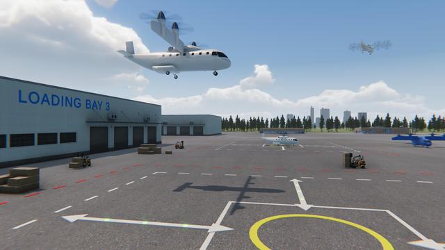
NASA is uniquely qualified to help revolutionize the Advanced Air Mobility cargo transportation industry by finding solutions for faster and cleaner modes of moving packages, using both large cargo delivery aircraft and small package delive…
Advanced Air Mobility Cargo Delivery
Test of Unmanned Aircraft Systems Traffic Management (UTM) technical capability Level 2 (TCL2) at Reno-Stead Airport, Nevada. During the test, five drones simultaneously crossed paths, separated by altitude.  Two drones flew beyond visual l…
UTM Technical Capabilities Level 2 (TLC2) Test at Reno-Stead Airport.
The drone follows an autonomously defined path around the modified C-141 Kuiper Airborne Observatory, (KAO) (NASA-714), on the N211 apron.  The drone photographs the aircraft with a visible and infrared camera which are processed using a ph…
Kuiper Airborne Observatory (KAO) Demolition
Test of Unmanned Aircraft Systems Traffic Management (UTM) technical capability Level 2 (TCL2) at Reno-Stead Airport, Nevada. During the test, five drones simultaneously crossed paths, separated by altitude.  Two drones flew beyond visual l…
UTM Technical Capabilities Level 2 (TLC2) Test at Reno-Stead Airport.
Test of Unmanned Aircraft Systems Traffic Management (UTM) technical capability Level 2 (TCL2) at Reno-Stead Airport, Nevada. During the test, five drones simultaneously crossed paths, separated by altitude.  Two drones flew beyond visual l…
UTM Technical Capabilities Level 2 (TLC2) Test at Reno-Stead Airport.